Trimble Applanix (Trimble®) has released its next-generation post-processing software, Trimble Applanix POSPac Complete, enabling geospatial professionals to deliver high accuracy and efficiency in crewed and uncrewed airborne (UAV), land, and marine mobile mapping and surveying applications.
The POSPac Complete combines Trimble ProPoint® positioning engine, post-processed Trimble CenterPoint® RTX (POSPac PP-RTX) and Applanix IN-Fusion+ multi-sensor aided inertial engine.
The geospatial software solution by Trimble is offered exclusively as an all-in-one term license that integrates essential GNSS augmentation options, including single base, Applanix SmartBase post-processed VRS, and POSPac PP-RTX service, into a single, transparent annual subscription.
This model eliminates hidden costs, streamlines budgeting, and ensures ongoing access to software updates, while Trimble RTX removes the requirement for base stations and provides reliable global coverage.
Because Trimble RTX is embedded within the software, users can achieve seamless and efficient workflows with centimeter-level accuracy anywhere in the world, even in remote or hard-to-reach areas, significantly increasing productivity in mapping processes.
Trimble Applanix POSPac Complete also saves valuable time by eliminating the need to set up and manage base stations, which can be time-consuming and complicated, especially when working with different local datums or epochs.
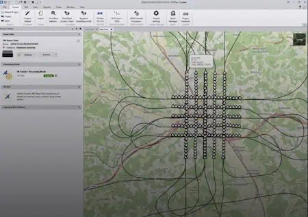
The new POSPac Complete features a modernized user interface with a background map and a streamlined project wizard, making workflows easier and more efficient for a better user experience.
Trimble’s software includes Trimble IonoGuard™, detecting and mitigating the effects of ionospheric scintillation, which is crucial during the solar activity peaks. This feature is supported in both single base and PP-RTX processing modes.
Nico Jaeger, product manager at Trimble, stated, “The new POSPac Complete is more than just a software update; it’s a paradigm shift in how geospatial professionals achieve high-accuracy results because of Trimble’s unique RTX factor.
“By integrating the power of PP-RTX directly into the software, we’ve eliminated the logistical headaches of base stations and streamlined the entire workflow, making mobile mapping more accessible than ever before. Altogether, it helps new and experienced users to produce survey-grade results with unprecedented speed and simplicity, truly representing the next generation of geospatial processing software.”
Optional Add-on Features:
There are other optional add-on features available for purchase too. The camera QC tools, the robust successor to CalQC, provide rapid IMU-to-camera boresight calibration for both single-head and multi-head (oblique) camera configurations. This process requires minimal user interaction.
LiDAR QC tools offer IMU-to-LiDAR boresight calibration and trajectory adjustment using advanced SLAM techniques. The latest version adds support for automatic ground control point (GCP) detection, the RIEGL LiDAR native file format, and reduced RAM requirements, supporting faster processing.
The POSPac Complete solution will be available in November 2025 through the Trimble sales channels, and will be showcased at INTERGEO 2025.
For more information or to request a demo, visit the Appleanix Trimble website >>