Areté

verified This business has been claimed by Areté and verified by UST.
Verified companies work with us to ensure we display the most up-to-date and comprehensive product information, articles and other material to help you choose the right solution for your requirements.
Cutting-Edge Unmanned Systems-based Sensing Solutions & Counter-UAS Systems for Military & Defense Forces United States of America
Visit Website
Saved
Save
Contact
Areté

Cutting-Edge Unmanned Systems-based Sensing Solutions & Counter-UAS Systems for Military & Defense Forces

Areté is a leading developer of drone- and unmanned systems-based sensing solutions and counter-UAS systems that provide unparalleled levels of awareness and protection for military and defense forces.

Leveraging cutting-edge science and engineering and a wealth of multi-domain expertise, we have provided our products in support of all four primary branches of the U.S. military, as well as the Missile Defense Agency and the U.S. intelligence community.

UAV & Ground Solutions

LiSA

Situational awareness LiDAR for degraded visual environments

LiSA Lidar for Situational AwarenessLiSA  (Lidar for Situational Awareness) is an airborne sensor that is designed to provide tactical visibility and understanding of hazards, obstacles, flight paths and landing zones under harsh weather conditions and in degraded visual environments (DVE). With a range of up to 2 km, it delivers real-time 3D spatial awareness, and enables safe operations at night and in the face of heavy rain, fog, snow, sand, smoke and more.

The low-SWaP solution is DO-178C certified, emits no RF, and is not detectable in the visible band or by NVG sensors.
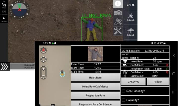
AIMS

Remote location, characterization and monitoring of human casualties

AIMSAIMS Automated Image-based Monitoring System (Automated Image-based Monitoring System) is a platform-agnostic system that can be installed on a range of UAS or UGV platforms to provide real-time detection of humans and monitoring of vital signs without the need for contact sensors. Running on low-SWaP COTS computing hardware, it offers a very high positive detection rate and an extremely low false alarm rate.

The powerful system can automatically detect and geolocate human bodies at up to 500ft away, and can identify body positions and detect heart and respiration rates as well as wounds. It is TAK-compatible and is ideal for battlefield medicine as well as first responders and SAR teams.

TANDOM

Real-time sensor fusion & tactical display output

TANDOMTANDOM Real-time sensor fusion & tactical display output (Tactical ANalytic Decision Optimization Module) provides real-time fusion capabilities for any application requiring immediate integration of multiple sensors and sensor modalities, including chemical, radiological, biological, video, and environmental. Designed to reduce cognitive burden, it allows operators to focus on high-confidence events, enabling swifter decision making and detecting events that may previously have been missed.

The TANDOM software runs on a mini-PC using industry-standard I/O protocols, and automatically fuses diverse sensor inputs into an intuitive tactical display with an exceptionally low false alarm rate.

ALLSEEN

AI & deep learning-powered automatic target recognition

ALLSEENALLSEEN automatic target recognition (ATR) (Areté Learned Likelihood Statistical Error Estimation Network) is a powerful AI- and deep learning-powered automatic target recognition (ATR) software that enables simultaneous detection, localization and characterization of objects within a scene. Fast, retrainable, and scalable, it provides operators with meaningful confidence estimates, thus reducing cognitive burden.

ALLSEEN can be easily integrated into a variety of UAV and UGV platforms, and is sensor-agnostic with only limited communication bandwidth requirements.

Maritime & Naval Solutions

AMSI

Advanced multispectral maritime imaging for minefield & obstacle identification

AMSIAMSI Advanced multispectral maritime imaging (Advanced Multispectral Imager) is a state-of-the-art sensing solution designed to provide real-time detection of mines and obstacles in littoral environments through the surf zone. Intended as an update for the proven AN/DVS-1 COBRA system, it incorporates a passive multispectral sensor and a powerful real-time processing unit with over 287 TFLOPS of performance.

PILLS

Bathymetric LiDAR for littoral surveillance & coastal mapping

PILLS (Pushbroom Imaging LiDAR for Littoral Surveillance) is a Joint ONR NAVAIR-funded SBIR program that provides unparalleled capabilities for high-resolution bathymetric data collection, and is ideal for both defense and commercial requirements.

PILLS Bathymetric LiDAR for littoral surveillance

The low-SWaP sensors have been deployed on both the Seahunter and Schiebel CAMCOPTER S-100 UAS, and can be used to carry out hydrographic surveys, detailed coastal and nearshore mapping, and alternate detection missions.

VCM

Maritime surveillance payload for tactical UUVs

VCMVCM automatic target recognition and maritime surveillance (Video ATR Common Module) is a modular passive EO wet payload for UUVs (unmanned underwater vehicles), enabling real-time high-accuracy automatic target recognition and maritime surveillance. The system utilizes a suite of powerful algorithms that provide a range of functionality including video enhancement, video mosaicking. image compression and LED lighting control.

The low-SWaP payload features onboard data storage and archival capabilities.

Counter-UAS Solutions

Basilisk

360-degree detection of individual UAS threats & drone swarms

BasiliskBasilisk 360-degree drone threat detection is a passive electro-optical detection and tracking solution that provides 360-degree coverage against a wide range of modern drone threats, including individual drones as well as multiple swarms in high-clutter environments.

The device provides reliable operation at distances of up to 5 km, and requires just 2 pixels per detection.

The low-SWaP system is composed of a modular sensor head, ruggedized off-board processor, and COTS hardware running multiple neural network classifiers for low false alarm rates and high detection confidence.

ART

Radar processing framework for counter-drone surveillance

ART (Areté Radar Tracker) is a radar processing framework designed to provide enhanced counter-UAS processing capabilities for modern micro-radar platforms. Scalable and customizable for a wide range of requirements, it provides significantly increased Range-to-Detect and improved performance against slow-moving and low-radar cross section targets.

ART Radar processing framework for counter-drone surveillance

The software runs on low-SWaP processing hardware, and can be used to support cued target tracking and multi-sensor tracking.

Products

LiSA

Situational awareness LiDAR for degraded visual environments

AIMS

Remote location, characterization and monitoring of human casualties

TANDOM

Real-time sensor fusion & tactical display output

ALLSEEN

AI & deep learning-powered automatic target recognition

AMSI

Advanced multispectral maritime imaging for minefield & obstacle identification

PILLS

Bathymetric LiDAR for littoral surveillance & coastal mapping

VCM

Maritime surveillance payload for tactical UUVs

Basilisk

360-degree detection of individual UAS threats & drone swarms

ART

Radar processing framework for counter-drone surveillance

Articles

Latest
UxV-Based Sensing Solutions & Counter-Drone Systems for Military & Defense

Areté's products have supported all four primary branches of the U.S. military, as well as the Missile Defense Agency and the U.S. intelligence community

Jan 05, 2026
Partnership to Advance Tactical Maritime UAS Operations

Areté and Parallel Flight will collaborate to integrate the Firefly heavy-lift UAS with the PILLS LIDAR system for enhanced littoral surveillance

Aug 09, 2024
Regional Offices & Locations
Areté HQ - Signal & Information Processing, Modeling & Simulation United States of America 9301 Corbin Avenue, Suite 2000, Northridge, CA 91324 +1 (818) 885-2200 Contact Website
Physical Oceanography & Marine Sensor Applications United States of America 3130 Fairview Park Drive, Suite 700, Falls Church, VA 22042 +1 (703) 413-0290 Website
Missile Defense United States of America 200 West Side Square, Suite 850, Huntsville, AL 35801 +1 (256) 203-6429 Website
Electro-Optics & Laser Solutions United States of America 6450 Dry Creek Pkwy, Niwot, CO 80503 +1 (303) 651-6756 Website
Optical Engineering & Low Rate Electro-Optic Sensor Production United States of America 3194 N Swan Road, Tucson, AZ 85712 +1 (520) 571-8660 Website
Multispectral Ground Processing and Exploitation Systems United States of America 315 Edge Avenue, Valparaiso, FL 32580 +1 (850) 865-1401 Website
Stabilized Vision Technologies United States of America 501 Grove Street, Healdsburg, CA 95448 +1 (818) 885-2200 Website
Advancing Unmanned Systems Through Strategic Collaboration UST works with major OEMs to foster collaboration and increase engagement with SMEs, to accelerate innovation and drive unmanned systems capabilities forward.