


Geospatial Analysis Software and GIS for Mapping and Data Insights
Geospatial analysis is the process of collecting, interpreting, and visualizing geographic data to understand spatial patterns, relationships, and trends. It plays a vital role in industries such as urban planning, environmental monitoring, disaster response, agriculture, and defense. Using geographic information systems (GIS), mapping applications, and advanced geospatial analysis software, organizations can make data-driven decisions based on real-world spatial insights.
Unmanned systems, such as drones and autonomous sensors, have enhanced geospatial analysis by improving data collection speed and accuracy. At the same time, geospatial analysis contributes to better navigation, situational awareness, and decision-making for autonomous systems. This category explores the core aspects of geospatial analysis, its applications, and the role of GIS software in mapping and spatial data processing.
Category Presented by


Suppliers
Add your company
Trimble Applanix
Precision Positioning & Orientation Solutions for Unmanned Applications
Platinum Partner

Exail
Inertial Navigation & Positioning Technology for Unmanned, Autonomous Systems
Platinum Partner


SatLab Geosolutions
GNSS Positioning Systems, 3D SLAM & Mobile Mapping, Unmanned Surface Vehicles
Gold Partner
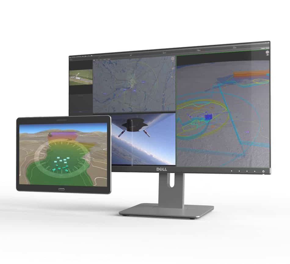
Kongsberg Geospatial
Geospatial Software for Real-Time Mapping, Data Visualization & Situational Awareness
Gold Partner


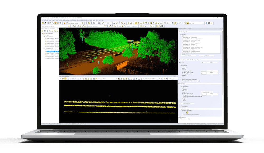
Blue Marble Geographics
Geospatial Data Analysis, Point Cloud Processing and GIS Mapping Software for Drones and UAV
Silver Partner

CHC Navigation
GNSS Positioning & Navigation Systems, Mobile Mapping UAV LiDAR & Unmanned Surface Vehicles
Silver Partner
Showcase your capabilities
If you design, build or supply Geospatial Analysis Software, create a profile to showcase your capabilities on this page
Products


Geospatial Analysis Software and GIS for Mapping and Data Insights

What is Geospatial Analysis?
Geospatial analysis involves processing and analyzing data tied to specific geographic locations. This includes the use of GIS mapping, remote sensing, and spatial modeling to extract insights from geographic information. The data is typically collected through satellite imagery, LiDAR scans, aerial photography, and GPS systems.
The results of geospatial analysis are used for a wide range of applications, from creating highly detailed maps to performing predictive modeling for environmental changes. By using GIS platforms and geospatial databases, analysts can track geographic patterns, monitor resources, and optimize land use planning.
Key Applications of Geospatial Analysis
Geospatial analysis plays a fundamental role in various fields, enabling better decision-making and resource management:
Urban planning & smart cities
City planners and engineers use GIS mapping software and geospatial databases to design efficient infrastructure, manage transportation networks, and optimize land use. Smart city initiatives rely on spatial analysis and big data to improve traffic management, energy distribution, and environmental sustainability.
Environmental monitoring & conservation

Global Mapper Mobile by Blue Marble Geographics
Geospatial analysis helps scientists track deforestation, study climate change, and monitor wildlife habitats. Remote sensing software and GIS services enable real-time monitoring of air and water quality, supporting conservation efforts worldwide.
Disaster management & risk assessment
Predictive modeling and spatial analysis are essential for disaster preparedness and response. GIS mapping software helps emergency teams assess risk areas, map evacuation routes, and coordinate relief efforts. UAV mapping software allows drones to capture post-disaster imagery for rapid damage assessment.
Precision agriculture and farming
Farmers and agricultural scientists use GIS platforms and drone mapping software with agricultural drones to monitor crop health, analyze soil conditions, and optimize irrigation. By leveraging geospatial solutions, precision agriculture improves yield predictions and reduces resource waste.
Surveying and land management
Surveyors and cartographers rely on geospatial analysis to create high-accuracy maps, assess land use, and conduct topographic studies. GIS mapping software and drone photogrammetry tools enable the development of 2D and 3D visualizations for real estate, construction, and natural resource management.
Security, surveillance and defense
Geospatial analytics software enhances situational awareness for defense and security operations. Law enforcement agencies use geospatial databases and GIS mapping tools for crime mapping, threat detection, and surveillance planning. Military applications include mission planning, border security, and reconnaissance operations.

Geospatial data analysis and GIS mapping software by Blue Marble Geographics
Geospatial Analysis Techniques and Technologies
A variety of geospatial analysis techniques help organizations derive insights from geographic data:
- Spatial analysis – Identifies spatial relationships and trends, used in urban planning and logistics.
- Network analysis – Optimizes routes and transportation systems, vital for supply chain management and emergency response.
- Cluster analysis – Detects geographic patterns, such as disease outbreaks or population distribution.
- Proximity analysis – Evaluates distances and spatial relationships, used in disaster response and land-use planning.
- Predictive modeling – Uses historical geospatial data to forecast environmental and economic changes.
Geospatial Software and Tools
Advanced GIS software and mapping platforms process and visualize geospatial data:
- GIS mapping software – Used for creating and analyzing geographic data layers.
- Remote sensing software – Processes satellite imagery, LiDAR data, and aerial photography.
- Geospatial databases – Store and manage large-scale geographic datasets.
- 3D mapping software – Generates detailed digital models for surveying, engineering, and city planning.
- Drone photogrammetry software – Converts UAV-captured images into high-resolution geospatial maps.
How Unmanned Systems Contribute to and Benefit from Geospatial Analysis

YellowScan CloudStation LiDAR Point Cloud Processing Software
Unmanned systems, particularly drones and autonomous sensors, play a growing role in geospatial data collection. These systems enhance traditional mapping and surveying by providing real-time, high-resolution imagery and LiDAR scans. Drones equipped with geospatial mapping software can cover vast areas quickly, capturing critical data for agriculture, infrastructure monitoring, and disaster response.
At the same time, geospatial analysis supports unmanned systems by improving navigation, situational awareness, and operational planning. Autonomous vehicles rely on GIS mapping, GPS data, and geospatial databases to operate efficiently in complex environments. From UAV route optimization to AI-driven terrain analysis, geospatial intelligence is essential for the advancement of unmanned technologies.
The Future of Geospatial Analysis
With the rise of AI, big data, and cloud-based GIS platforms, geospatial analysis is becoming more powerful and accessible. Machine learning algorithms enhance predictive modeling, while real-time geospatial analytics drive faster decision-making in industries such as transportation, environmental science, and security. The increasing integration of unmanned systems into geospatial data collection and analysis will continue to push the boundaries of mapping technology and spatial intelligence.
As organizations across various sectors harness the power of geospatial analysis, its impact on global decision-making and resource management will only grow. Whether used for urban development, environmental protection, or precision farming, geospatial analysis remains at the forefront of innovation in mapping and geographic intelligence.


