Image Processing & Analysis Software
Find suppliers of Image Processing & Image Analysis Software for images and data captured by unmanned vehicles, Drones, UAV, ASV, RPAS
Category Presented by

Suppliers
Add your company


Kongsberg Geospatial
Geospatial Software for Real-Time Mapping, Data Visualization & Situational Awareness
Gold Partner


Sightline Intelligence
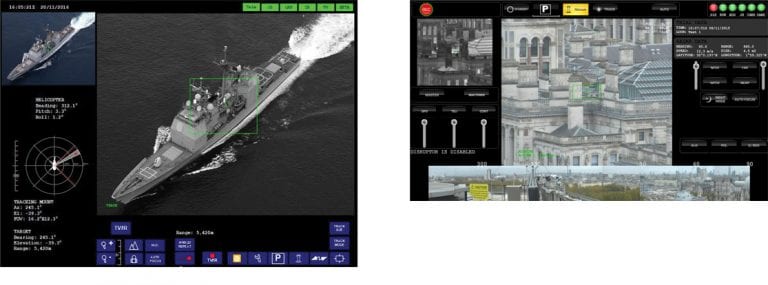
Onboard Video Processing Software and Hardware for Unmanned Systems
Gold Partner

Overwatch Imaging
Advanced Imaging & Sensor Autonomy for Time-Critical Airborne Intelligence Missions
Silver Partner

Sense Aeronautics
Cutting-Edge AI-powered Drone Video Analytics Solutions for Object Detection
Silver Partner

Nearthlab
AI-Powered Autonomous Drone Solutions for Public Safety, Defense, and Industrial Inspection
Silver Partner
Cambridge Pixel
Radar Software & Sensor Processing Solutions, Maritime Radar Control, Tracking & Visualization for USV
Silver Partner

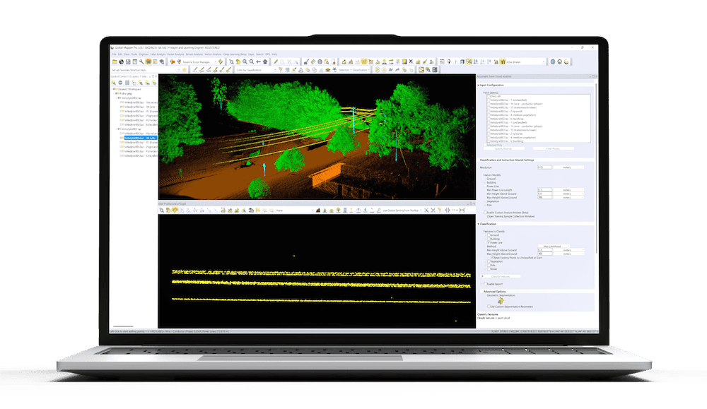
Blue Marble Geographics
Geospatial Data Analysis, Point Cloud Processing and GIS Mapping Software for Drones and UAV
Silver Partner
Showcase your capabilities
If you design, build or supply Image Processing & Analysis Software, create a profile to showcase your capabilities on this page
Products
Image Processing & Analysis Software

Drone Image Processing & Analysis Software
Drone image processing and analysis software allows users to perform photogrammetry on aerial imagery and LiDAR data collected by unmanned aerial vehicles such as drones, UAS, UAV and RPAS.
Aerial imagery and LiDAR data is captured by drones flying autonomously along a series of waypoints, taking images or measurements at regular intervals. Images will have an overlap to ensure no detail is missed, and will be processed by image stitching software. Images are also geotagged to provide accurate location.

Applications for Image Processing Software
Image processing software is used by professionals in a wide variety of industries, including mapping, surveying, urban planning, precision agriculture, forestry, oil and gas, and mining.
In addition to RGB imagery, drone image processing software may also work with NDVI (normalized difference vegetation index) images and other indexes for precision agriculture, as well as thermographic images for building heat maps.
Image processing can also be used to perform volumetric calculations, which analyse volumes of features or regions of interest on the outputted maps. These are often used in the construction industry to measure amounts of material such as gravel in a stockpile, or to calculate an amount of earth to be removed or to be used to fill in a pit.
Using drones and image processing software for these types of calculation is both safer and more convenient than traditional survey methods and requires far less resource.
 Image Analysis Software and Drone Mapping
Image analysis software is used extensively to process drone acquired data in order to produce detailed and accurate maps. Capable of outputting 2D and 3D models and maps, UAV image processing software can be used to create digital models documenting the elevation, terrain and surface of photographed areas. This detailed information is invaluable to mapping drone applications and can also be used when simulating flight plans.
Advanced Drone Image Processing
Drone image processing and analysis software may include a variety of advanced features such as intelligent feature identification and extraction algorithms and on-the-fly editing tools. It may allow for scalable distributed processing across networks and multiple hardware platforms, or provide the ability to upload images to the cloud for processing, taking advantage of powerful servers instead of limited desktop computers.